If you are a little interested in the world of sailing, then you couldn’t have missed the event of the year: the Vendée Globe. The start of the edition was given on November 8th in Les Sables d’Olonne and the racers are currently off the Azores, in the middle of the Theta depression. You can of course follow the race live on the official Vendée Globe website, but if you want to experience it from the inside, you too can race! Virtual Regatta reproduces the race conditions identically, and more than 700 000 players are on their IMOCA at the moment.
You too want to get into the adventure and put all the chances on your side? Then nothing better than to help you with a routing to plan your trajectories.
In this article, we tell you all about how to do your routing with SailGrib for the Vendée Globe on Virtual Regatta, under Android. And it’s all accessible to beginners!

If you are not playing it yet, start by downloading Virtual Regatta
If you are not yet in the game, you must first download Virtual Regatta Offshore. And even if the official start of the race took place 7 days ago, Virtual Regatta has everything planned: a virtual frigate is positioned in the middle of the pack and you will be immediately placed on it when you create your account. This way, you won’t leave 7 days late.
Once the account is created, validated and the game launched, you will have to choose a nickname. And if you feel like it, don’t hesitate to join us in the team we have created: “Team Sailing Kerguelen”.
I won’t go into details about the game’s interface and how to play it, it’s not the purpose of this article, but the options are quite clear and intuitive.
Download SailGrib to create your routing for the Vendée Globe
SailGrib, which is also one of our partners in our adventure, is a navigation application that allows you to read weather files, do your routing, see currents, tides and much more. SailGrib exists in free and premium versions. It is possible to do the routing on the free version, but the routing distance is quite limited. With the free version of SailGrib, you will have to run by very small sections instead of larger ones. The free version is limited to 50NM and 48-hours weather forecast.
On your phone or tablet, go to Google Play (SailGrib is only available on Android) to download SailGrib. That’s it, you’re ready to perform like Armel Le Cléac’h ! Not really, but it’s already a good start.

Switch to "Virtual Regatta mode" on SailGrib WR
SailGrib is equipped with a rather nice mode: the “Virtual Regatta” mode. This mode simulates your position according to the weather conditions, your starting point and your arrival point. Without it, your boat would be positioned where you actually are right now, so of course it’s less convenient to sail alongside the Vendée Globe racers.
To activate this mode, go to the menu, then select at the bottom “Settings“, then “Virtual Regatta“. The “Virtual Regatta mode” embeds the polars of the IMOCA of the Vendée Globe. If the update is not done automatically, then click on “Update polars“.


Now that SailGrib is configured to make you experience the Vendée Globe, it’s time for the actual routing.
First step of the Vendée Globe routing: define your starting point and your arrival point
All routing is based on a starting point, an arrival point (and possibly intermediate points) as well as a weather file. Let’s start with the starting point and the arrival point.
When you do a Dunkirk => Ramsgate, the starting and arrival points are quite clear. On the other hand, you can imagine that for a round-the-world trip, your starting and arrival points cannot be “Les Sables d’Olonne”. It will take you more than two months to circumnavigate our planet and weather forecasts obviously don’t go that far.
I detail below the steps you will have to go through to do your routing as well as a summary in pictures.
Define your starting point
If you had taken the race from the beginning, then the starting point was quite clear: Les Sables d’Olonne. But what about now that the race has started, and you’re getting a little bit further ahead with each passing hour. It’s quite simple: this is where your boat is currently positioned! To find it in Virtual Regatta, you have to click in the top right corner where your logbook is as shown in the screenshot below :

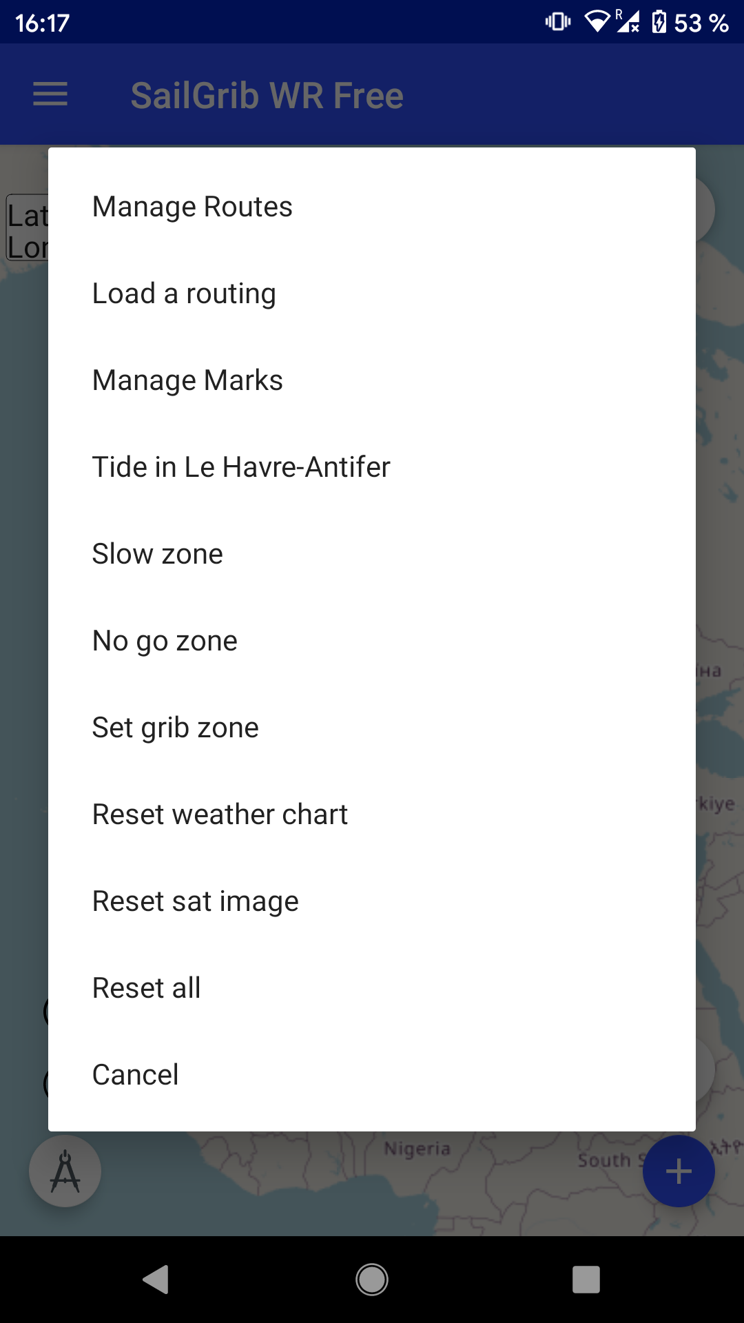
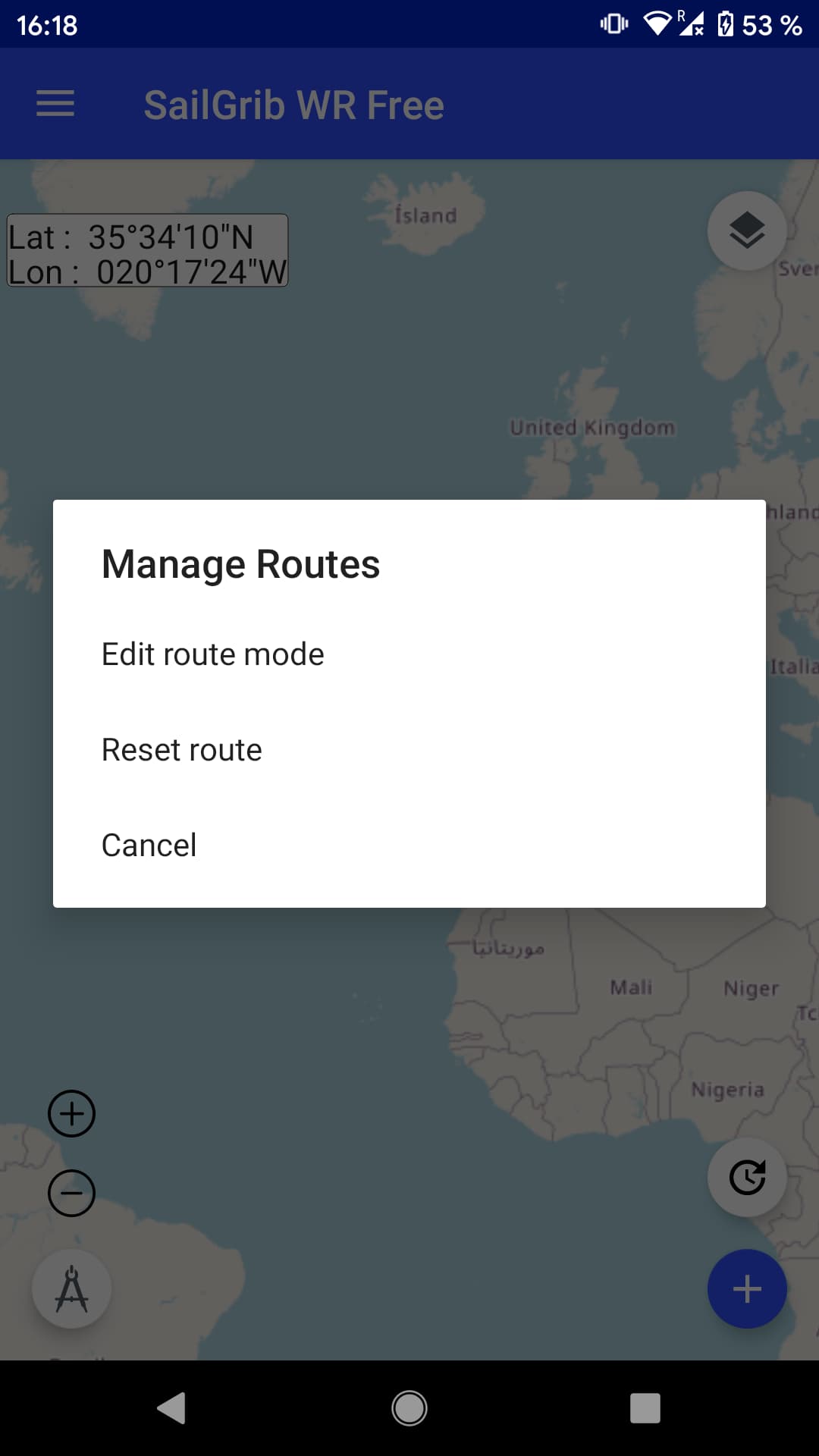
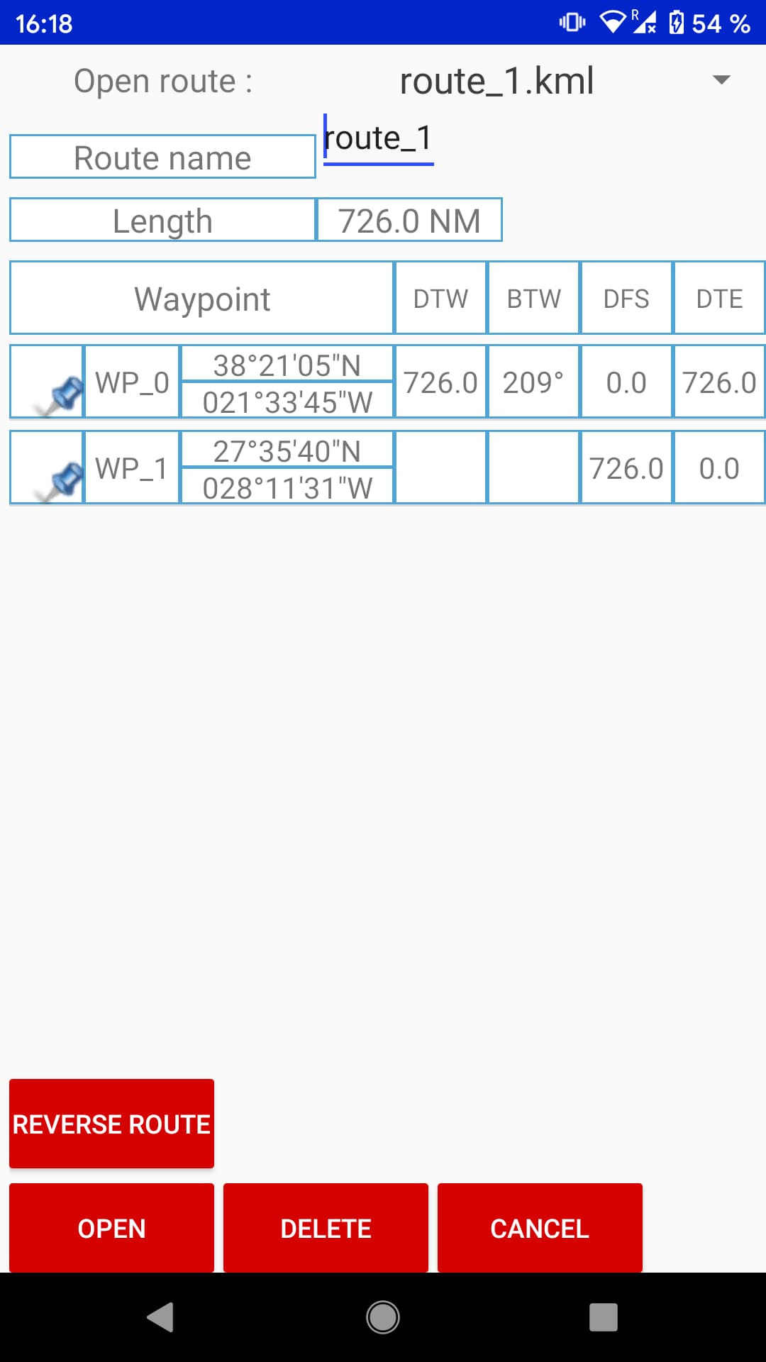
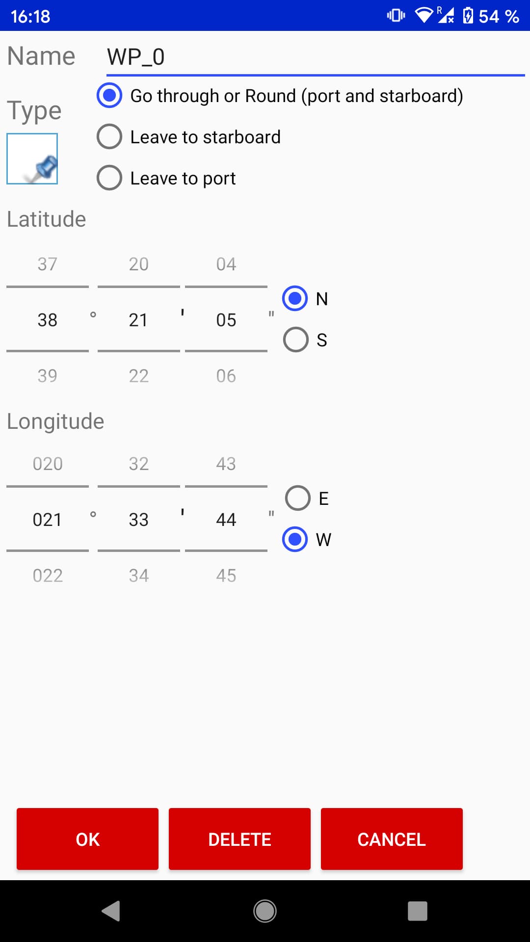
Once you have retrieved the GPS coordinates in Virtual Regatta, go on SailGrib to create a route. You have to do a long press in the middle of the screen, then “Manage routes” => “Create a route” => “Give a route name: VendeeGlobe2020” . By default, the first point (waypoint) will be created where your cursor is when creating the route. Don’t panic, it is possible to edit it afterwards. I couldn’t figure out how to enter specific GPS coordinates for the starting point by hand the very first time. The trick is, once this first point is created, to first place its arrival point and then come back to edit its starting point. So place your arrival point as I explain in the next paragraph, then make a long press in the middle of the screen then “Manage routes” => “Load a route” and click on your first Waypoint “WP_0”. Here you have the possibility to enter the GPS coordinates of where your IMOCA is located (in my case: 31°N27′23″ 025°W55′46).
At each new routing, just repeat this procedure of editing the starting point and place your starting point at your new position.
Define your arrival point
So what if our arrival point can’t be Les Sables d’Olonne? We’ll have to divide our journey in several stages. Not too small stages, but not too big ones either. For example, a route “Les Sables d’Olonne” => “Cape of Good Hope” is clearly a too big stage. But a stage from “Les Sables d’Olonne” to a point in the middle of the Atlantic Ocean between France and Brazil makes sense. Just as the next stage could take us off Brazil, then the South Atlantic and then the Cape of Good Hope.
To have a better idea of the route taken during this race, you can go to this address on the tracking of the runners of the Vendée Globe 2016. By placing your mouse on the map as the candidates pass by, you will have in the bottom left corner the GPS coordinates corresponding to this point.
Do not worry too much about the accuracy of the point placed. The Vendée Globe is 22,000 nautical miles (40,000 kilometers) to cover, which means that we are not too picky about placing a point within a 2 kilometers range.
For our first point, I position it right in the middle of the Atlantic, off the coast of Senegal by doing a long press at the right place then “Add a waypoint to the route”, then click on “Finish” at the bottom of the screen.
A summary of the creation of the start and end points
If you are a little lost, here is a complete summary of the actions to be done in order:
- Create a first starting point by making a long press in the middle of the screen, then "Manage routes" => "Create a route" => "Give a route name: VendéeGlobe2020". At this moment, a first point is automatically created. Wherever it is, we will edit it later.


- Create a waypoint in the mid-Atlantic off the coast of Senegal by doing a long press at the right place then "Add waypoint to route" and click "Finish" at the bottom of the screen.

- Edit the starting point with your current Virtual Regatta coordinates. Go to the game, then to your logbook, and retrieve the coordinates here.
- Go back to SailGrib, make a long press in the middle of the screen, then "Manage routes" => "Edit route Mode" => click on the "Edit" button at the bottom of the screen => click on WP_0 => change the coordinates by those retrieved on Virtual Regatta. This step is to be repeated each time you do a new routing in order to position your routing starting point on your current position.
Now you are ready to proceed to the weather file recovery and routing step.
Second step of the Vendée Globe routing : get your weather file (grib)
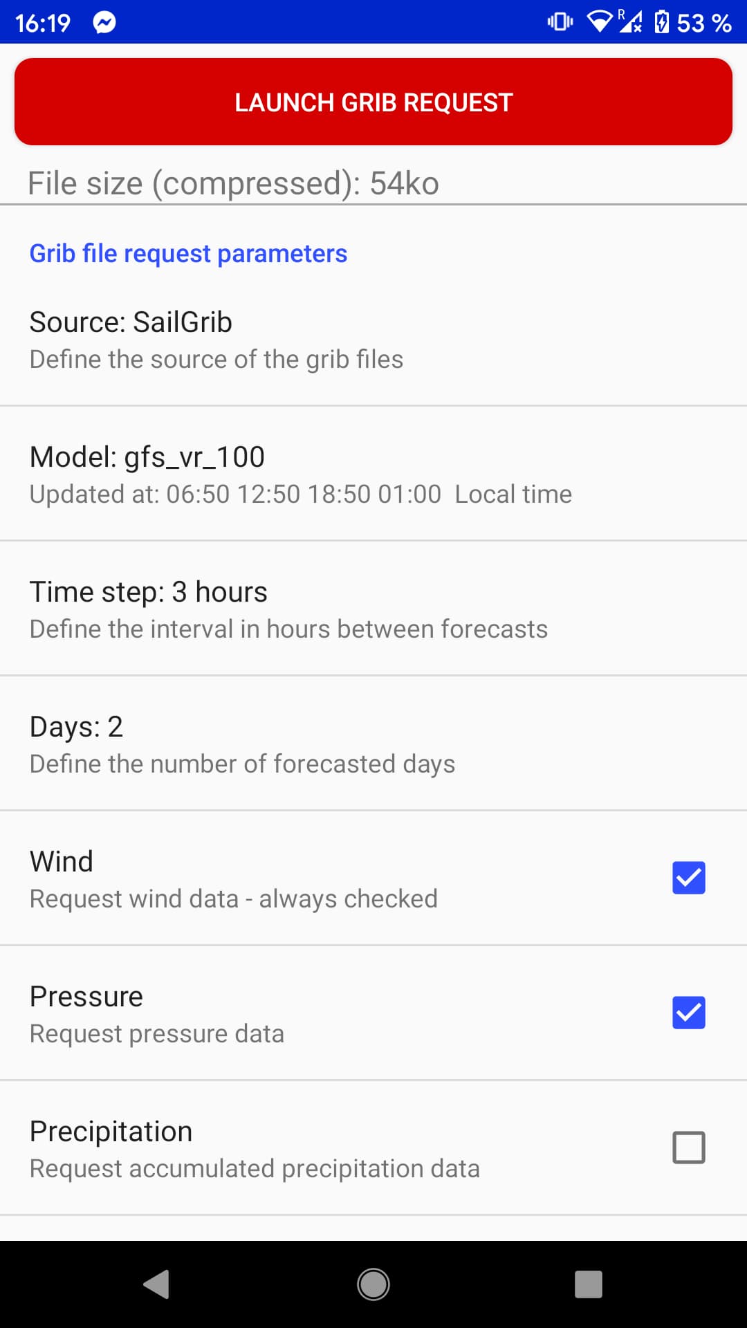
We have just created our route, it is now necessary to retrieve a weather file to proceed with our routing. To retrieve the weather file, position the zoom so that your route is covered by the entire screen, then press the “+” at the bottom right, then “GRIB Query”.
The weather model is already pre-selected and we use the GFS model for Virtual Regatta in mesh 1°. We keep a time step of 3 hours. Concerning the number of days, it seems to me to be limited to two days on the free version of SailGrib. On the Premium version, you can go up to 15 days. It’s obviously much better to have the weather at 10 or 15 days, but if you play Virtual Regatta for fun, the two-day version is more than enough. You can uncheck the Precipitation and Cloud Cover which will not add any value to the routing.
Once the settings are correct, click on “GRIB Query” at the top of the screen and SailGrib will download the weather file.

Third step of the Vendée Globe routing: do your routing
Here we are at the actual routing step, finally! We have our route, our weather file, we just have to ask SailGrib to calculate the fastest route between our starting point and our arrival point. To do this, click again on the “+” at the bottom right => then “ROUTING”. Some parameters have to be changed on this screen :
-
Route
Make sure you have selected the route you have just created "VendeeGlobe2020" -
Start date
The date on which you do the routing -
Start time
The time at which you do the routing, or even more precisely the time at which you retrieved your position in GPS in Virtual Regatta. Because yes, your boat keeps moving forward, it doesn't wait for you even when you leave the app! -
Polar
Select the polar imoca_vendee_2020 which corresponds to the polar of the IMOCAs of this year's Vendée Globe. -
Polar efficiency
You have the possibility in Virtual Regatta to put polish on your hull. If you chose this option, check the Polish box a little lower and your efficiency will increase to 100.3%. -
Pro sails
Virtual Regatta gives the possibility to purchase additional sail sets. If you did, then check this box and SailGrib will use this option to best calculate your trajectory with the sets of sails you have. -
Current sails
Fill in here the sail currently in use on Virtual Regatta. This has a (small) impact because a sail change takes time and your boat moves slower for a short time if a sail change is necessary. -
Foils / Winches pro
If you have taken foils and/or pro winches in Virtual Regatta, check the corresponding box(es) -
Tack or gybe penalty and sail change penalty
Activate tacking and sail change penalties
There you go, you can now start your routing. SailGrib starts calculating the best optimized route.
How to properly read your routing and apply it in Virtual Regatta?
That’s all well and good, but what do we do with our routing now? Let’s go to the detailed table by clicking on the button that looks like an Excel table at the bottom right. This table gives us all the steps to reproduce to follow the routing that has just been done. It is obviously impossible to reproduce this routing to the degree of accuracy, for several reasons. The first one is that Virtual Regatta, in the free version, only allows you to enter two programming points (and up to 15 in the paid versions), but above all any automatic system, which is moreover predictive, has its flaws. For example, it is not uncommon for SailGrib to ask for a tack for one minute of sailing.
So you have to read the table carefully to draw your own conclusions. If, for example, SailGrib recommends a 110° course for two hours, then 112° for two hours, then 111° for hours, with the wind angle on the boat always the same, it is surely not necessary to change the course by one degree every two hours on Virtual Regatta. In the same way, it can sometimes be good to choose a course to keep, while it may be better to choose a wind angle to keep in other cases.
But in this case, it is your talent and experience as a skipper that will do the talking!

Join us in the Team Sailing Kerguelen on Virtual Regatta
A little challenge? How about a race between us? Join the “Team Sailing Kerguelen” on Virtual Regatta to find our position in the race. Don’t hesitate to send us a message directly on Virtual Regatta to tell us who you are!


15 Responses
Thank you! However, on the free version of the app I cannot create any route longer than 150 NM.
How did you manage to route for 700 NM with the free app?
Hi Claudio, yes you’re right, the free version is limited to 50NM and 48 hours weather forecast, which is very limited. You have two options here :
– either you go with the premium version (around 30e/year)
– or you go with another software, for example qtVlm (10 days weather forecast with unlimited routing)
Thank you!
Firstly thankyou for your instructions.
A question. Any idea how to deal with the exclusion zones. I am in the VR mode but my routing takes me into the iceberg zone.
Mike
Hi Mike,
The post is not translated yet to english, but you can find all instructions here : https://sailingkerguelen.com/routage-vendee-globe-comment-integrer-zones-navigation-interdites-sailgrib-wr/
I’m sure Google Translate will work just fine on this article, and it’s really straightforward :
– download the files from this post and upload them to the folder sailgrib/nogozone on your smartphone/tablet
– activate the nogozones in SailGrib
and that’s it 🙂
If you have any questions do not hesitate.
Merci Jeremy pour la information
Je fais des cours de français pour étrangers en ce moment alors peut-être que je n’aurai pas besoin de Google!
Mike
Sorry english again.
I have a problem. I loaded the exclusion zone files as instructed, but now cannot run a weather routing. When I press the ‘Run’ button nothing happens. Any ideas?
Did you pick a correct date and time ?
how to get a polar of VR imoca plus pro sails to export for other routing tools??
Right here : http://toxcct.free.fr/polars/ 🙂
oh, sure let me check it out! thx!
ok, from SailGrib files I’ve got separate files for every sail (jib.pol etc.) and the general imoca_vendee_2020.pol – how do I compile it?
Hi,
I have two boats in Virtual Regatta for my first time doing it, both started after the start on day 1 and 2. One in VIP/Full Pack (Cape de Bonne Esperance ~5000), the other the standard/Free version(over a day behind).
Questions:
1) Can I use Sailgrig to Route for both sailboats?
2) Is it easy to switch from one to the other?
3) I have been using QTVlm. Is there a link describing what are the added functionalities with Sailgrib with VR and in real?
Looking forward to trying it and possibly adopting it for my weather and routing.
Thank you
Donat
p.s.: I speak french fluently if you prefer to reply in French. thx
Hey Donat,
Since we are on the english version of the website, I’ll answer in english :=)
1) Sure, you can create several routes. Then update the position of your boats on their respective routes. Same for the weather routing, you can select for which route you want the routing.
2) Very easy, it’s just a dropdown for the weather routing. And it’s just a list with checkboxes to select routes.
3) Hum, to my knowledge I’ve neven seen such a list. I’m not using qtVlm for a long time so I don’t know the pros and cons yet.
That’s really nice post. I appreciate your skills. Thanks for sharing.